Spain's geography.
Click on the image to see Spain on the satellite.
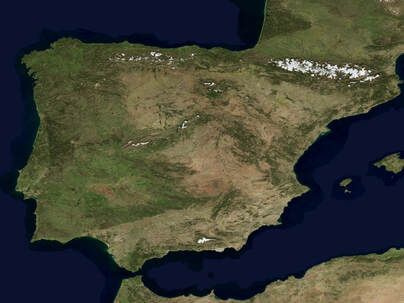
Spain’s territory consists of a large part of the Iberian Peninsula, the Canary Islands in the Atlantic Ocean, the Balearic Islands in the Mediterranean Sea and the autonomous cities of Ceuta and Melilla, located on the north coast of Africa.
All of Spain’s territory is located in the Northern Hemisphere. Peninsular Spain shares a border with France and Andorra to the north and with Portugal, which is also on the Iberian Peninsula, to the west. The Cantabrian Sea and the Atlantic Ocean border the north and west coast of the Peninsula and the Mediterranean Sea borders the south and east coast.
The Balearic Islands are an archipelago in the Mediterranean Sea. The Canary Islands, however, are an archipelago located almost 1000 kilometres southwest of the Peninsula, in the middle of the Atlantic Ocean, just north of the coast of Africa.
Spain is a country with varied terrain and a high average altitude. Spain’s high average altitude is due to the numerous mountain ranges and systems located throughout the country and the fact that a high inner plateau occupies a large part of the Peninsula. The islands are also mostly mountainous and have got significant elevations, especially in the Canary Islands.
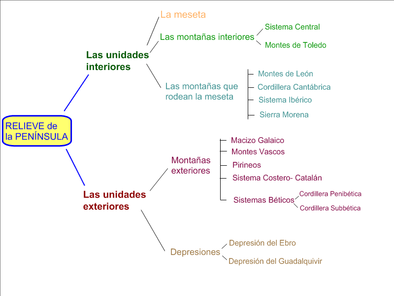
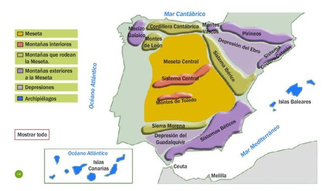
Main landforms:
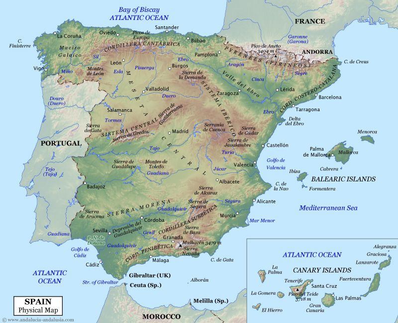
The Meseta.
The Meseta’s interior
The Meseta is the plateau at the centre of the Peninsula. Its average altitude is 650 metres. It covers Castilla y León, Castilla-La Mancha, Madrid and Extremadura. The rivers that travel through it drain their waters into the Atlantic Ocean. Two mountain systems are located within the Meseta.
• The Central System stretches from the Iberian System to central Portugal. It divides the Meseta in two: the northern sub-plateau, home to the Duero Valley, and the southern sub-plateau, home to the Tajo and Guadiana valleys. It is divided into the mountains of Somosierra, Guadarrama, Gredos (which includes Almanzor, the highest peak that rises to 2592 metres) and Gata.
• The Toledo Mountains are a smaller system. They separate the Tajo Valley from the Guadiana Valley in the southern sub-plateau.
The Meseta’s borders
• The Mountains of León form the northwestern edge of the Meseta. The Mountains of León include the Teleno Mountains and the Segundera Mountains, where elevation rises to around 2000 metres.
• The Cantabrian Range runs parallel to the coast on the northern edge of the plateau. Its highest summit is Torrecerredo (2648 metres, in the Picos de Europa).
• The Iberian System is located on the Meseta’s eastern edge. It includes the Picos de Urbión, the Albarracín Mountains and the Moncayo Mountains, with its highest peak, Moncayo (2313 metres).
• The Sierra Morena is located on the southern edge of the Meseta. Its most notable mountains are the Aracena Mountains, the Hornachuelos Mountains and the Madrona Mountains, which include the highest peak, Bañuela (1323 metres).
Mountain ranges in the North of Spain.
• The Galician Massif is located in the northwest corner of the country. The notable Cabeza de Manzaneda peak, in the middle of the Massif, rises to 1778 metres.
• The Basque Mountains are located in the north of Spain. They are between the Cantabrian Range and the Pyrenees. One of the highest peaks is the Aizkorri (1528 metres).
• The Pyrenees are a large chain of mountains in the northeast of Spain. They stretch from the Cantabrian Sea (Gulf of Bizkaia) to the Mediterranean Sea (Cape Creus). It is a natural border between Spain to the south and France to the north. The Aneto is the highest peak (3404 metres).
• The Catalan Coastal Range, runs parallel to the Mediterranean coast. It is between the Pyrenees and the mouth of the Ebro River. Its highest peak is the Turó de l’Home (1712 metres).
The Baetic System in the South os Spain.
The Baetic System is a large mountain system in the southeast of the Iberian Peninsula. It is made up of two mountain ranges: the Penibaetic and the Subbaetic Ranges. Between these two ranges, a series of small valleys, form the Intrabaetic Basin.
• The Penibaetic Range is closer to the southern coast of the Mediterranean Sea. It contains the Ronda Mountains, the Baza Mountains and the Sierra Nevada. The highest peaks, such as the Veleta (3396 metres) and the Mulhacén (3478 metres), are in the Sierra Nevada. The Mulhacén is the highest peak on the Peninsula.
• The Subbaetic Range is located, next to the southern edge of the Meseta. The Cazorla Mountains, the Segura Mountains and La Sagra Mountains are among its most notable mountains.
Depresions outside the meseta.
Depressions are low, flat areas of land. Because of their low elevation, it is common for rivers to run through them. There are two large depressions located between the border of the Meseta and the outer mountain systems: the Ebro Depression and the Guadalquivir Depression.
The Ebro Depression is the larger of the two depressions. The Pyrenees lie to the north, the Catalan Coastal Range to the east, and the Iberian System to the south and west.
In the Guadalquivir Depression The Sierra Morena lies to the north and northwest of the depression, the Subbaetic Range to the northeast and the Penibaetic Range to the southeast.
Interactive map: check your learning! |
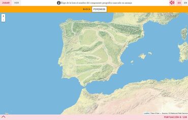
Click on the image to play!!
|
Spain's archipelagos.
The Balearic Islands are mostly mountainous, as they are an extension of the Subbaetic Range. The highest altitude is the peak of Puig Major (1 445 metres), which is in the Tramuntana Range.
The Canary Islands are mountainous and volcanic in origin. The highest peak in Spain is the Teide, measuring 3 718 metres.
The Canary Islands are mountainous and volcanic in origin. The highest peak in Spain is the Teide, measuring 3 718 metres.
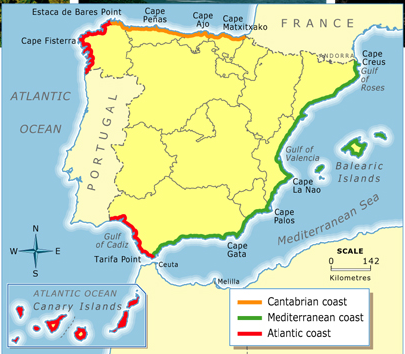
Coastal landforms
 Click on the image to check your learning!
Spain has got about 7880 kilometres of coastline. Peninsular Spain and its islands are mostly surrounded by rocky cliffs. The coast of peninsular Spain can be divided into five sections.
• The Atlantic coast of Cantabria
• The Atlantic coast of Galicia
• The Atlantic coast of Andalucía
• The Mediterranean coast of Andalucía
• The Eastern Mediterranean coast Ceuta and Melilla are autonomous cities found south of the Mediterranean Sea.
• The Atlantic coast of Cantabria
• The Atlantic coast of Galicia
• The Atlantic coast of Andalucía
• The Mediterranean coast of Andalucía
• The Eastern Mediterranean coast Ceuta and Melilla are autonomous cities found south of the Mediterranean Sea.
The rivers of Spain
Watersheds in Spain.
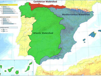
Watersheds are the dividing lines of mountain ranges. They are areas of land which descend from high ridges. Rivers on the same watershed flow into the same sea.
Spain has three main watersheds:
Spain has three main watersheds:
- The Cantabrian watershed has short, fast-flowing rivers. Their flow is abundant and regular: the Nervion, the Bidasoa, the Navia and the Nalon.
- The Mediterranean watershed occupies about one third of Spain. The rivers are short, with the exception of the Ebro. Their flow is irregular: the Ebro, the Jucar and the Segura.
- The Atlantic watershed occupies over half of Spain. The flow of the rivers is abundant and regular: the Miño, the Duero, the Tagus, the Guadiana and the Guadalquivir. The Tagus is the longest river in Spain.
Interactive map:
|
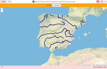
Click on the image to play!
|
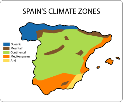
Spanish climates and vegetation.
|
Interactive map: check your learning! |
POPULATION
Population is the total number of people living in an area.
Demography is the study of population, how it evolves and why it changes.
Demography is the study of population, how it evolves and why it changes.
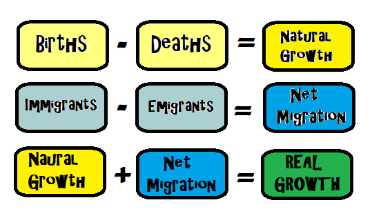
Spain's population is getting old (ageing) because of two main factors:
1. Decrease in birth rate. Women are having children later and fewer babies.
2. Increase in life expectancy. Nowadays people live longer due to all the medical advances, hygiene and healthy life habits.
1. Decrease in birth rate. Women are having children later and fewer babies.
2. Increase in life expectancy. Nowadays people live longer due to all the medical advances, hygiene and healthy life habits.
Why do people emigrate?
People can move to another part of the country (internal migration) or they can move to live abroad (international migration).
- Internal migration. Rural exodus: People living in villages migrate to big cities and coastal areas in search of work.
- International migration: People move to another contry in search of work, escaping from poverty and wars.
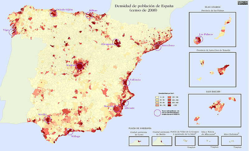
Population density in Spain.
Rural population is usually older and the density is lower.
Urban population is usually younger and the density is higher.
Spain has a population of 47.000.000 inhabitants. Rural areas are the least populated. The most populated areas of Spain are: Madrid, cities on the coast and both archipelagos.
|
|
|
